Trip notes · Arizona
Glen Canyon to Lees Ferry
The last stretch of Glen Canyon has no rapids, sheer sandstone walls and water cold enough to be dangerous. Dress for the water and it makes a good first big-canyon packraft trip.
Last checked November 2026
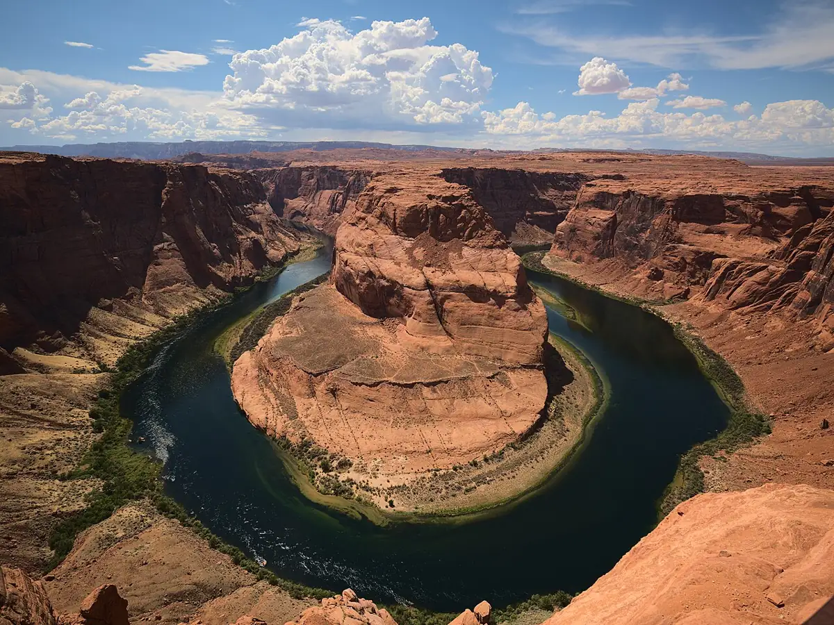
Below Glen Canyon Dam, the Colorado River flows through about fifteen miles of red Navajo Sandstone walls before reaching Lees Ferry. Lees Ferry is where Grand Canyon river trips launch. The water is drawn from deep in Lake Powell and leaves the dam cold and very clear, usually green, with trout visible on the gravel. There are no rapids. The river moves steadily, and you can drift past Horseshoe Bend at water level, a view most people only see from the overlook on the rim above.
Route overview
River miles on this reach are counted upstream from Lees Ferry, so the dam sits at roughly mile minus 15 and the ramp at mile 0. The canyon runs deep and narrow for the whole distance, with sandstone walls rising several hundred feet straight from the water in places. Horseshoe Bend is in the upper half, a tight meander you float around in about half an hour. Lower down the walls open a little, side canyons with petroglyph panels and short walks appear, and the last miles before the ramp pass gravel bars popular with anglers.
There is no road access between the dam and the ferry. Once you are on the water, the only ways out are downstream to the ramp or back up by motorboat.
| Plan | Distance | Time on water | Good for |
|---|---|---|---|
| Paddle up from the ramp, float back | a few miles | half a day | Calm water, no booking needed |
| Backhaul partway up, float down | about 6 to 10 miles | a full day | First visits, short days |
| Backhaul to the upper reach, float the whole way | about 15 miles | one long day or an overnight | Seeing Horseshoe Bend from the river |
Getting on the water
You cannot launch at the dam. Upstream travel ends at three closure buoys about a quarter mile below it, and going past them needs a separate Bureau of Reclamation permit. Most paddlers start at the Lees Ferry ramp and pay an authorized concessioner to carry them and their boats upstream by motorboat, the so-called backhaul, then paddle back down. Some book a drop near the top of the reach and float the full distance. Others get dropped partway up and spend a night on the way back. The current is usually gentle enough that some people simply paddle upstream from the ramp along the eddies and float back.
Everyone using a watercraft between the dam and Lees Ferry needs the free Lees Ferry Backcountry Permit, one per group, filled out at the self-service kiosk above the launch ramp. You drop one copy at the kiosk and carry the other. It does not reserve a campsite. All occupants of hand-powered boats on this reach must wear a Coast Guard-approved life jacket while underway, which means on your body and zipped, even on the flat. Glen Canyon National Recreation Area charges an entrance fee at Lees Ferry, and interagency passes are accepted. Confirm current concessioner options and rules with the NPS before you go.
- Check the dam release schedule and the Lees Ferry gauge for your dates.
- Book a backhaul with an authorized concessioner if you want to start upstream.
- At the ramp, pay or show your pass and fill out the Lees Ferry Backcountry Permit at the kiosk.
- Load the boats on the backhaul with life jackets on and gear in dry bags.
- Agree on a turnaround time and a meeting point at the ramp before you split up.
Flows and the cold
The river level depends on dam releases, which change during the day as power demand changes. A sandbar you camp on in the evening can be underwater by morning, so pull boats well up the beach and tie them. The USGS gauge at Lees Ferry (09380000) shows the daily swing, and the flows and gauges guide explains how to read it. At very high releases the park requires bigger motors for upstream travel, which can affect backhaul plans. The water stays cold all year, typically in the 40s to low 50s °F.
Upstream wind is the other common problem. Afternoon gusts in the canyon can stop a light packraft, so start early and stay out of the middle of the river when the wind picks up.
Hazards
- Cold water causes the worst outcomes. A capsize far from shore can disable you before you reach the bank.
- Upstream wind can pin a packraft in place for an hour. Hug the shore and use eddies.
- Motorboat wakes from backhauls and fishing boats are steep in a narrow canyon. Turn your bow into them.
- Rising water at night floats away untied boats. Tie off to something solid.
- Summer heat on the sandbars is intense. Carry shade and plenty of drinking water; the river water must be treated.
Camping
The reach has primitive campsites along the river with toilets at some of them. Upstream river camps carry no camping fee, but you still need the free river permit. Camping rules, fire restrictions and human-waste requirements are set by the NPS, so check them when you pick up the permit. Bring a waste kit if the site you plan to use has no toilet. Kayak Beach in the upper reach closes each spring and summer for osprey nesting; check posted closures. Pack out all trash and follow Leave No Trace practice on sites that see daily use.
A sample overnight
A typical two-day plan: book an early backhaul to the upper reach, float to Horseshoe Bend in the cool of the morning, and spend the afternoon on a camp in the middle of the reach out of the wind. On day two, float the lower miles before the afternoon gusts, stop at a side canyon for a walk, and reach the ramp by midday. Pack a full set of dry clothing in a sealed bag, a stove, a waste kit and a sleeping bag rated for the cool canyon nights; see the packing list. In spring and fall, a drysuit and warm layers are worth the weight even on flatwater.
The Waterholes Canyon approach
Some canyoneers reach this stretch of river from above. They descend Waterholes Canyon, a narrow slot that crosses Navajo Nation land south of Page, down a series of rappels, including one very long drop to the river. Then they inflate packrafts and float the last few miles to Lees Ferry.
One party who did the route twice, a few years apart, found that flash floods had changed the canyon a lot between visits. Pools, debris and anchors were all different. They described cold, debris-filled swims in the narrows, a long multi-stage rappel that needs careful rope work to avoid a notorious crack, and a late-day float on emerald water under walls turned orange by the sun.
Treat it as a technical canyoneering route. It needs a permit from the Navajo Nation for the canyon, two vehicles, full rappel gear and solid rope skills. Talk to someone who has done it recently, because floods rearrange it. The packrafting and canyoneering article covers the gear overlap.
Skill level and who it suits
With no whitewater on the reach, you need flatwater skills, a forward stroke strong enough for a headwind, and the habit of staying near shore. Because of the cold, beginners should go with someone experienced and practice re-entry somewhere warm first. The reach suits first-time canyon paddlers, photographers and anglers; the reach is also a well-known trout fishery, and the packraft fishing notes cover rigging a boat for it.
Packraft notes
Any packraft handles the water itself. A spray deck and inflatable floor help with cold and wind more than with waves. Wear a paddling life jacket that fits over your drysuit. Lees Ferry is the start of the Grand Canyon, and the warm-water contrast is the Lower Salt. More options are on the Arizona page.
Can I put in at Glen Canyon Dam?
Not on your own. Public boats cannot go above the closure buoys below the dam. Most packrafters take a concessioner backhaul from Lees Ferry and float back down.
Do I need a permit?
Yes, the free Lees Ferry Backcountry Permit, one per group, from the kiosk above the launch ramp. You also pay the recreation-area entrance fee or show a pass.
How cold is the water?
Cold all year, typically in the 40s to low 50s °F. Dress for immersion.
Can I camp along the river?
Yes, at primitive river campsites. They are first come, first served, and the permit does not reserve one.
Is it a good first packraft trip?
For confident flatwater paddlers who dress for the cold, yes. There are no rapids, though wind and cold still make it a serious day out.