Skills · planning
River flows and gauges
A river's difficulty changes with how much water is in it. Checking a gauge before you leave home is the easiest safety step in packrafting.
Last checked November 2026
Most rivers in the United States have at least one stream gauge, an automated station that measures water level and calculates flow every 15 minutes or so. The US Geological Survey runs thousands of them, and state agencies and dam operators run more. Trip reports, guidebooks and river descriptions all describe conditions in terms of these numbers, so learning to read them lets you compare what you will find with what someone else found.
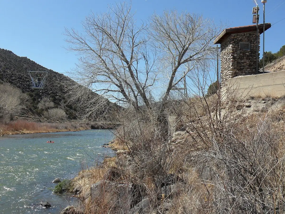
Each reading comes from one spot, usually a bridge or cableway, and tells you how much water is passing there. Working out what that means for the rapids twenty miles downstream takes some interpretation.
The two numbers
Discharge in cfs is the number most packrafters use. One cubic foot of water is about 7.5 gallons, so a river running 1,000 cfs moves roughly 7,500 gallons past the gauge every second. Gauge height is useful on some smaller creeks where local paddlers mark levels on a bridge pier, but it only means something at that one gauge. Some rivers in Canada and elsewhere report in cubic meters per second (cms); 1 cms is about 35 cfs.
How discharge is worked out
A gauge does not measure flow directly. It records the water level (USGS spells it "gage height"), and the agency converts that level to discharge with a rating curve built from field measurements, where hydrographers measure depth and current speed across the channel. Floods move gravel, beavers build dams and ice forms in winter, so the curve drifts. That is why recent numbers are marked provisional and can be revised months later. For trip planning this rarely matters, but it explains why a reading during ice-up or right after a big flood can look strange.
| Discharge (cfs) | Gage height (ft) | |
|---|---|---|
| What it measures | Volume of water per second | Height of the water surface at the station |
| Comparable between rivers? | Roughly, as a sense of size | No, each gauge has its own reference point |
| Comparable over years at one gauge? | Yes, the usual choice for trip reports | Can shift if the channel changes |
| Where paddlers use it | Most runs and most guidebooks | Small creeks, painted bridge marks, some older guides |
Finding a gauge
Search for the river name and "USGS" or use the USGS water dashboard at dashboard.waterdata.usgs.gov, which shows gauges on a map. American Whitewater river pages also list the gauge used for each run along with suggested minimum and maximum flows. Make sure you use the gauge that matches your section. A gauge below a large tributary can read far more than the stretch above it.
USGS now serves its stream data through Water Data for the Nation, which has replaced the older NWIS web pages. Each station has a monitoring location page, named with the agency prefix and site number (for example, USGS-07091200), with a hydrograph of recent readings at the top and links to statistics and longer records further down. Bookmark the pages for the rivers you run often; it saves searching every time.
Judging a flow
A reading means little until you compare it with something. A flow of 500 cfs is a healthy level on a small creek and a scrape on a big desert river. What matters is how the reading compares with the range for that particular river.
| Compared with the usual range | What you can expect |
|---|---|
| Below the suggested minimum | Rocks exposed, more dragging and portaging, pins possible in narrow slots |
| Low to medium | Usually the friendliest level for packrafts; slower current and clear lines |
| Medium to high | Faster current, bigger waves, stronger eddy lines, fewer places to stop |
| Above the suggested maximum | Holes and hydraulics grow, eddies wash out, wood moves, swims become long; often a reason to stay off |
| Near flood stage | Do not go |
Check the hydrograph as well as the latest reading. A steep rise means rain or melt is arriving and the river will keep climbing. A steady line means stable conditions.
Packrafts react to flow differently from big rafts. A light boat bounces off rocks that would pin a heavy one, so low water is often more forgiving in a packraft. High water hits packrafts harder: a short, light boat gets stopped by holes and folded on eddy lines that an 18-foot raft punches through. When a trip report comes from a rafting or kayaking source, read the flow they mention with that in mind.
Rising and falling rivers
The direction of the trend matters almost as much as the number. A river at 1,200 cfs and dropping is a different day from the same river at 1,200 and climbing fast.
- A rising river carries more debris, picks up wood from the banks and can change a rapid between your scout and your run. Eddies you planned to use may disappear.
- A falling river is usually clearer and more predictable, though rocks and strainers that were covered a day earlier start to appear.
- A flat line on a dam-controlled river may be a scheduled release that can change on short notice.
- A spike after a storm can pass in hours on a small desert creek, and it can carry mud, logs and a wall of brown water with little warning.
In the desert Southwest, summer thunderstorms many miles away can raise a canyon river with no rain where you stand. Check the forecast for the whole drainage upstream of you.
Reading the snowmelt pattern
During runoff, the hydrograph on a mountain river looks like a saw blade: one tooth a day. Sun warms the snowpack, meltwater drains into the channel, and the pulse travels downstream at the speed of the current. Close to the snow, the daily peak comes in the afternoon. Far downstream it may arrive overnight or the following morning. Hot days and warm nights make the teeth taller; a cold front can flatten them for a few days. Once you know the timing at your gauge, you can pick the part of the day when your section is lowest.
Dams and releases
Rivers below dams follow release schedules rather than weather. Glen Canyon Dam, for example, varies flows in the Colorado River through Lees Ferry and the Grand Canyon over the course of each day. On dam-controlled rivers, check the operator's release schedule as well as the gauge, and pull boats well up the beach at night. The Glen Canyon and Lees Ferry notes cover this in more detail.
A worked example
Say you are planning a day on Browns Canyon of the Arkansas River in Colorado, described on the Browns Canyon trip page. The usual reference is the USGS gauge "Arkansas River near Nathrop, CO" (site 07091200), which sits upstream of the canyon.
- Two or three days out, open the monitoring location page for USGS-07091200 and look at the last seven days of discharge.
- Note the shape. During runoff you will probably see daily peaks; in late summer, a flatter line.
- Compare the current reading with the range given for the run on American Whitewater and with the flow named in any trip report you are using.
- Check the forecast for warm weather or storms in the upper valley, which would push the numbers up.
- The evening before, check again. If the trend is steeply up and the river is already near the top of your comfortable range, choose an easier section or a different day.
- On the morning of the trip, take one last look before you drive. Note the reading so you can link what you see on the water to the number.
Over a season, those notes add up to your own flow guide, with lines like "this rapid gets pushy above X" or "this eddy disappears above Y" for the sections you run most.
Putting it together
- Find the gauge for your section and the flow range recommended for the run.
- Check the reading and the trend the day before and on the morning of the trip.
- Compare with the level in your trip report or guidebook, not just the grade.
- If the flow is near the top of the range, scout more, take more safety gear or pick a different river.
On multi-day trips, you lose the gauge once you leave signal. Look at the trend and the snowpack or release schedule before you go, mark a high-water line at camp each night with a stick, and plan your campsites as if the river might rise. The journal guide to planning a packraft trip covers building flows into a trip plan, and the Labyrinth Canyon notes show how a big, slow desert river behaves across a season.
Common mistakes
- Reading a gauge on the wrong fork or below a big tributary.
- Looking only at today's number and ignoring the trend.
- Treating a raft or kayak trip report's "good flow" as a good flow for a packraft.
- Forgetting that the snowmelt peak reaches the lower river hours after it leaves the mountains.
- Assuming a dam-controlled river will stay flat overnight.
Flow changes the difficulty grade and the shape of every rapid. Learn how high and low water change features with the river reading guide, and check the cold-water advice because the highest flows usually come with the coldest water. If a higher flow catches you out, your swimming and rescue skills are the backstop. The Colorado river sections are a good place to start matching gauge readings to what you see on the water. Back to all skills.
What does cfs mean on a river gauge?
Cubic feet per second, the volume of water passing the gauge each second. It is the standard way paddlers in the US describe flow.
What is the difference between cfs and gage height?
Gage height is the water level in feet at one station, measured from a local reference point. Discharge in cfs is calculated from that level using a rating curve, and it is easier to compare across seasons and trip reports.
How often do USGS gauges update?
Most real-time stations record every 15 minutes and send data at regular intervals, often hourly. Recent data are provisional and may be revised.
What flow is good for packrafting?
It depends entirely on the river. Compare the current reading with the suggested range for that specific run, and remember that packrafts handle low water better than high water.
Why does the river rise in the afternoon?
On snowmelt rivers, the sun melts snow during the day and the pulse of meltwater reaches the river in the afternoon or evening, later the further downstream you are.