Journal · planning
Planning a packraft trip
Most packraft trips that go wrong were in trouble before anyone reached the put-in. A good plan is mostly a set of questions you answer at the kitchen table, in the right order and with enough lead time.
Last checked November 2026
Packrafting gives you freedom that other paddlers do not have. You can hike to the put-in, walk the shuttle and string together water that no road reaches. The catch is that fewer people have been down your line before you, so you have to do the homework yourself. The routine below works for an afternoon float and for a two-week traverse; the longer trip just needs more lead time.
The planning sequence
- Pick a route and write down the water you will paddle, the ground you will walk, and the likely time for each.
- Find out who manages the land and the river, then read their current rules on permits, camping, fires and waste.
- Research flows: find the nearest gauge, what level suits your skills, and how fast it can change.
- Sort the shuttle: a second vehicle, a bike, a hike, or a paid shuttle service.
- Study maps and satellite images for portages, exits, camps and hazards like dams or diversions.
- Choose gear for the coldest water and the worst weather you could meet, not the forecast.
- Write a trip plan and leave it with someone who will act on it if you do not check in.
Permits and flows decide whether the trip can happen at all, so check them before you spend evenings on gear lists. The shuttle often decides the dates, because a driver or a road can be the scarcest thing in the whole plan.
A planning timeline
A local float needs a few evenings of planning. A permitted desert river or a fly-in Alaska trip can need months. Drop the rows that do not apply.
| When | What to do | Why then |
|---|---|---|
| 6 months or more | Check whether the river uses a lottery or advance reservation, and note the application window | Some popular rivers allocate permits far ahead, and missing the window costs a season |
| 2 to 3 months | Settle the route, group and dates. Book flights, fly-in services or long shuttles | Shuttle companies and small-plane operators fill up in peak season |
| 4 to 6 weeks | Apply for or print non-lottery permits. Study the gauge history for your dates. Test any new gear on local water | Leaves time to fix a leaking valve or swap a paddle |
| 2 weeks | Confirm the shuttle in writing. Plan meals. Agree on group gear and who carries it | Group gear is where things get forgotten or doubled |
| 1 week | Check road conditions, fire restrictions and closures with the managing agency | Roads wash out and fire bans start with little notice |
| 48 hours | Check the forecast and the gauge trend. Write and send the trip plan | The flow you will meet is now mostly predictable |
| Morning of | Check the gauge one last time, confirm the turnaround rule, sign in at any trailhead register | Last chance to change the plan cheaply |
| After the trip | Check in with your contact. Dry and repair gear. Note the flow and how it ran | Your notes become the next trip's research |
Permits and rules
Rules differ more than you might expect. Some rivers need nothing. Others run a lottery months ahead, cap group size or require a portable toilet and fire pan. Land matters as much as water. A canyon approach may cross a national park, a BLM district, a national forest or tribal land, each with its own permits. The trip pages in this guide name the managing agency, and the official page from that agency is the only source to trust for current fees and dates.
Do not assume a packraft gets a pass because it is small. On permitted rivers it usually counts as a boat like any other. The Grand Canyon is a good example: a permit covers the trip, not the craft. Multi-day desert rivers such as Desolation and Gray canyons also have their own launch rules and required equipment, and those rules apply to a solo packrafter just as they do to a raft group.
Permit and rules checklist
- Who manages the river, each bank and the approach? Note every agency.
- Is a permit needed for day use, overnight use or both? Is it a lottery, a reservation or a self-issued form?
- Group size limits, and whether they count people, boats or both.
- Required gear: portable toilet, fire pan, life jackets of a certain type, a spare paddle.
- Camping rules: designated sites, distance from water, any closures for wildlife.
- Fire rules and current restrictions.
- Fishing or hunting licenses if you plan either.
- Dogs and vehicle passes: allowed or not, needed or not.
The waste and camp rules are easier to follow once they are habit. The leave no trace page covers what most agencies expect.
Flows and gauges
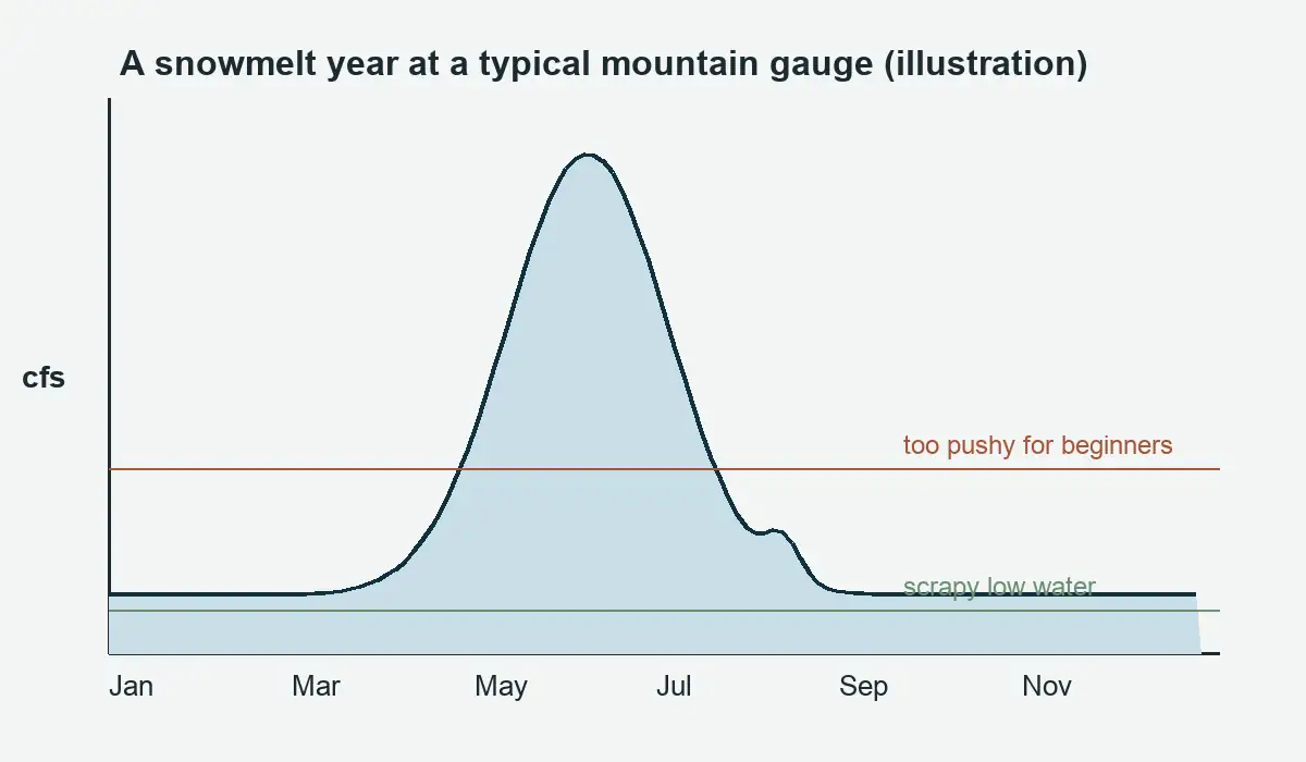
A river at one flow can be a gentle float and a week later a serious run. Look up the gauge history as well as today's reading. Dam-controlled rivers can rise or fall on a schedule, and snowmelt rivers often peak in the afternoon. The page on river flows and gauges explains how to read the numbers and what they mean in a small boat.
Flow checklist
- Which gauge is closest to your section, and is it above or below major tributaries?
- What flow range do trip reports and guidebooks describe as good for packrafts?
- What does the river look like at the low and high ends? Too little water can mean dragging for miles.
- Is the river dam-controlled? Find the release schedule if one is published.
- How fast does it rise after rain or a warm spell? Look at past storms in the gauge record.
- Which class of rapids does the section hold at your expected flow? The river difficulty classes page explains how ratings shift with water level.
- What is your walk-out flow: the level at which you hike instead of paddling?
Shuttles
| Option | Works well when | Watch out for |
|---|---|---|
| Two vehicles | Groups, long roads between ends | More driving, two parked cars |
| Bike shuttle | Short road, safe place to lock a bike | Traffic on narrow roads |
| Hiking shuttle | A trail follows the river or makes a loop | Time, daylight and pack weight |
| Paid shuttle | Long or remote routes | Book ahead, confirm the pickup |
| Upstream boat ride | Some dam tailwaters | Schedules and fees change |
Hiking shuttles are the one most other boaters cannot use. A loop that climbs out of a canyon and drops back to the river can replace hours of driving.
Shuttle checklist
- Is the take-out road passable for your vehicle in the season you plan? Some need high clearance or close when wet.
- Where exactly will the shuttle leave your car, and where are the keys?
- What happens if you are a day late? Agree on it with the driver.
- If you hike or bike the shuttle, how many hours does it add, and is there daylight for it?
- Is parking at both ends legal for the length of the trip?
Maps and the plan you leave behind
Carry a paper map even if you rely on a phone. Mark put-in, take-out, known portages and at least one exit point for every half day on the water. Satellite images help you spot logjams and braided channels, but they can be years out of date.
A trip plan template
| Field | What to write |
|---|---|
| Group | Names, ages, phone numbers, emergency contacts, relevant medical conditions |
| Route | River and section, put-in, take-out, planned camps, any hike-in or hike-out |
| Dates and times | Launch date, planned exit date, and the overdue time for calling for help |
| Vehicles | Make, color, plate, and where each is parked |
| Boats and gear | Boat colors, tent color, clothing colors, communication devices carried |
| Exits | Known escape routes and roads along the way |
| Turnaround rules | Flow, weather or time limits at which you change plans |
| Who to call | The managing agency or local sheriff, with numbers, and what to tell them |
Tell your contact how long to wait after the overdue time before calling, and make sure they know a satellite messenger can fail and a late group is usually just slow.
Worked example: a three-day Labyrinth Canyon float
Take a flatwater desert trip on the Green River in Utah. The route, mileages and permit steps are on the Labyrinth Canyon trip page; this is how the planning timeline lines up for it.
- Two to three months out, the group picks a spring date and decides to launch at Ruby Ranch and take out at Mineral Bottom, roughly 45 river miles over three days. They book a commercial shuttle first, because shuttles on this stretch fill faster than anything else.
- Six weeks out, the leader downloads the free BLM permit form, fills in launch and take-out, and emails it to the Moab office. The group reads the stipulations and adds a portable toilet system and a fire pan to the gear list.
- Four weeks out, they look up the Green River gauge at the town of Green River and compare spring flows in past years. Higher spring water means a faster current, fewer sandbar camps and colder water, so they pack drysuits.
- One week out, the leader calls the BLM about the Mineral Bottom road, which is dirt with steep switchbacks and can turn impassable when wet.
- Two days out, they check the wind forecast, since afternoon upstream wind is the main obstacle on this river. They agree to start early each day and to use the Bowknot Bend carry if the wind is strong.
- The trip plan goes to a friend at home with the overdue time set for the evening after the planned exit, allowing for a slow drive out.
On a whitewater river the steps are the same, with more weight on flow research and stricter turnaround rules.
Mistakes that wreck good plans
- Planning the paddling miles and forgetting the hiking miles with a full pack. Build slack into every day.
- Picking a take-out that turns out to be private land or a road closed for the season.
- Assuming phone coverage. Carry a satellite messenger on remote trips.
- Leaving rescue practice for the trip itself. Run through self-rescue drills with the group before you need them.
- Packing everything in one big bag, so a single leak soaks your sleeping bag. Split gear across several dry bags.
A last pass before you leave
The night before, check the forecast and the gauge again, and decide what would make you turn around. Writing that decision down before the trip is easier than making it at the put-in with friends watching. Pack using a packing list so nothing stays on the kitchen counter.
Plans change in the field, and a good one leaves room for that. The story in packrafting in the rain shows a group that went anyway and enjoyed it. The piece on ski and packraft trips shows what happens when a route that looked easy at the pub meets real ground. Route ideas are collected in the trips section, and more essays are on the Journal page.
How far ahead should I plan a packraft trip?
A local day trip needs a few evenings. Permitted multi-day rivers can need months, because some allocate permits by lottery or reservation well before the season. Check the managing agency's page for the application window.
Do packrafts need permits?
Wherever a river requires a permit, a packraft usually counts as a boat like any other. Small size does not exempt you from group size, toilet or fire pan rules.
What should a trip plan include?
Names, route, put-in and take-out, vehicles, gear colors, exits, turnaround rules, the overdue time, and who to call. Leave it with someone who will act on it.
How do I know if the flow is right?
Find the nearest gauge, compare today's reading with trip reports at known flows, and look at the trend. If you cannot find any guidance for your section, treat the trip as exploratory and plan more exits.